記事検索

Otto's blog

https://jp.bloguru.com/otto

Mountain climb graph

スレッド
Mountain climb graph
While trying to find out how high henro temple number 45 (Iwaya-ji) was, I found this interesting GPS graph. It was posted online by someone who cycled the same route. I think the beginning point is Matsuyama, & the final point is Iwaya-ji.

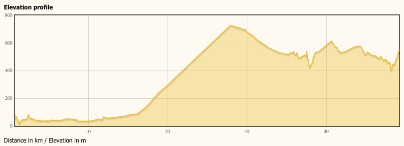
I feel tired just looking at it.
#アウトドア #旅行

ワオ!と言っているユーザー

  • ブログルメンバーの方は下記のページからログインをお願いいたします。
    ログイン
  • まだブログルのメンバーでない方は下記のページから登録をお願いいたします。
    新規ユーザー登録へ
* は必須項目です。必ずご記入ください

🙂 絵文字の使い方:
• キーボードのショートカットキー: Macの場合 - コントロール + コマンド + スペース、Windowsの場合 - Windows+ピリオド
• コピーペースト: お好きな絵文字をこちらから選び、テキストエディタにコピーペースト
  • なし
  • 中央
チェックされている場合は表示されます。
画像認証
michiko
michikoさんからコメント
投稿日 2012-11-16 14:36

I cannot image the height. Do you know how high Kinka mountain is. I don't know. He, he. But I don't think that I want to climb the mountain. I've been driven there only once or twice long time ago.

ワオ!と言っているユーザー

ハッピー
悲しい
びっくり